A geofence around a blast zone is only useful if the alert it fires actually reaches the right person, at the right urgency, before the equipment gets any closer. Most mine sites can draw a boundary on a map without much trouble. The harder problem is managing what happens the moment that boundary gets crossed, across dozens of zones, hundreds of alerts a shift, and a team that cannot afford to treat a workshop entry with the same urgency as a haul truck rolling into an active blast area. Mining geofence alert management software is built specifically to solve that second problem, turning raw GPS boundary events into alerts that are prioritized, routed, and acted on instead of buried in a notification feed. Sign up for FleetRabbit to set up governed geofence alerts across your entire site today.
Roughly 30 to 40 percent of mining fatalities involve vehicle interactions, and unmonitored boundary crossings around blast zones, restricted areas, and haul roads are a direct contributor. Sites that move from a single flat alert stream to tiered, routed geofence alert management cut restricted-zone incidents by more than half and reduce alert fatigue enough that critical warnings actually get acted on within minutes instead of getting lost in the noise.
Why Drawing A Geofence Is The Easy Part
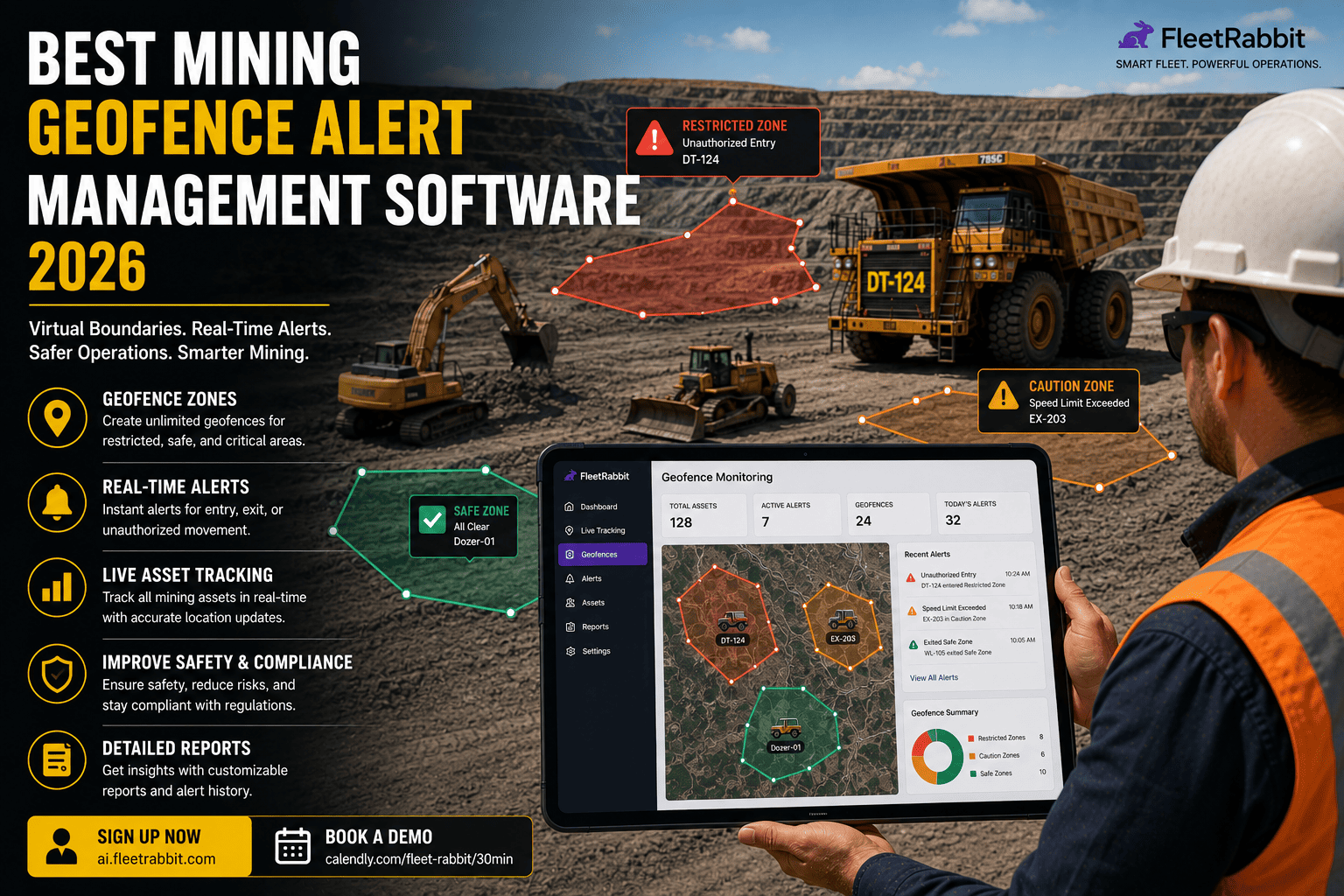
Any GPS platform can draw a circle or polygon on a map. What separates real alert management from basic geofencing is what happens after the boundary is crossed. A mine site typically runs several zone types at once, and each one carries a different level of urgency.
How Alert Management Turns Boundary Crossings Into Action
The difference between a flat alert feed and a managed one comes down to how events are classified, where they get routed, and how much noise the system filters out before it reaches a person.
Severity Tiering Instead Of One Flat Alert Stream
Every geofence event gets classified by urgency rather than treated identically. A blast zone breach triggers an immediate, unmissable alert. A workshop entry logs quietly for maintenance review. Without this tiering, teams either drown in low-priority notifications or start ignoring alerts altogether, which is worse than having no system at all.
Routing Alerts To The Right Owner
A restricted-zone breach and a recurring speeding event in a haul road zone do not belong on the same desk. The platform routes each alert type to the person who owns that response, whether that is HSE, a shift supervisor, or a maintenance planner, so nothing sits waiting for someone to notice it.
Filtering False Positives From Real Boundary Crossings
Poorly tuned geofences generate constant false alarms from GPS drift near a boundary edge, which trains teams to ignore the system. Polygon-based zones, not simple circles, plus a short dwell-time check before an alert fires, cut false positives dramatically compared to a basic circular geofence.
Offline Zones Still Get Enforced
Deep pits and underground sections often sit in cellular dead zones. A well-built platform keeps evaluating geofence boundaries on the device itself, queuing any breach event locally and pushing the alert the instant signal returns, so a dead zone never becomes a blind spot.
| Zone Type | Alert Severity | Typical Response Owner | Response Window |
|---|---|---|---|
| Blast Zone | Critical | Safety officer and equipment operator | Immediate, real-time push |
| Dump / Tip Zone | High | Zone supervisor | Within minutes |
| Restricted / Exclusion Area | High to Moderate | Site HSE team | Same shift review |
| Haul Road Speed Event | Moderate | Shift supervisor | End of shift coaching |
| Workshop / Fuel Zone | Informational | Maintenance planner | Logged for reporting |
FleetRabbit lets you map blast zones, dump zones, restricted areas, and haul roads once, then routes each alert to the right owner at the right urgency, so critical warnings never get lost in routine notifications.
Setting Up Alert Governance Without Overwhelming Your Team
Sites that roll out geofencing for the first time often make the same mistake: alerting on everything at once, which trains people to tune the whole system out within a week. A phased approach keeps alerts meaningful from day one.
Start With The Highest-Consequence Zones
Map blast zones and any area tied to a serious safety consequence first, and set those to immediate, unmissable alerts. Every other zone type can be added once the team has confidence the critical layer is not generating noise.
Set Escalation Paths, Not Just Notifications
A critical alert that goes unacknowledged within a defined window should escalate automatically to a supervisor rather than sitting in one person's inbox. This single rule closes most of the gap between an alert firing and someone actually acting on it.
Book a demo through FleetRabbit's scheduling page to walk through a zone and alert-tier rollout mapped to your specific site layout.
What Ungoverned Geofence Alerts Are Actually Costing You
Sites running a single flat alert feed typically see response times measured in hours rather than minutes, because the one critical alert a shift is buried among dozens of routine ones. With roughly 30 to 40 percent of mining fatalities involving vehicle interactions, every minute shaved off a critical-zone response has a direct safety payoff, separate from the operational cost of near-misses, incident investigations, and the production stoppages that follow a serious safety event. Tiered alert management is one of the lowest-cost changes a site can make relative to the risk it removes.
Key Takeaways On Mining Geofence Alert Management
Drawing a boundary around a blast zone or restricted area is the easy part. The real value comes from what happens after that boundary gets crossed: whether the alert reaches the right person, at the right urgency, fast enough to matter. A single flat alert stream either overwhelms a team into ignoring the system or buries the one critical warning that actually needed a response.
Tiered severity, clear routing, automatic escalation, and false-positive filtering turn geofencing from a mapping exercise into an active safety system. Sites that manage alerts this way cut restricted-zone incidents by more than half and get critical warnings acted on in minutes instead of hours. Given that vehicle interactions sit behind a large share of mining fatalities, that difference is not a minor operational upgrade.
FleetRabbit maps your blast zones, dump zones, restricted areas, and haul roads once, then routes every alert to the right person at the right urgency across your entire site. See how governed alerting looks on your own map before your next shift starts.