A photo attached to an inspection record proves something happened in front of a camera. It doesn't prove where. An inspector could photograph a berm on the east side of the pit and log it against the west highwall three kilometers away, and a standard digital checklist would accept it without complaint. On a site where ground control, highwall stability, and haul road condition all depend on someone physically standing in the right spot and looking closely, that gap between "a photo exists" and "the inspection actually happened here" is exactly what geotagging closes.
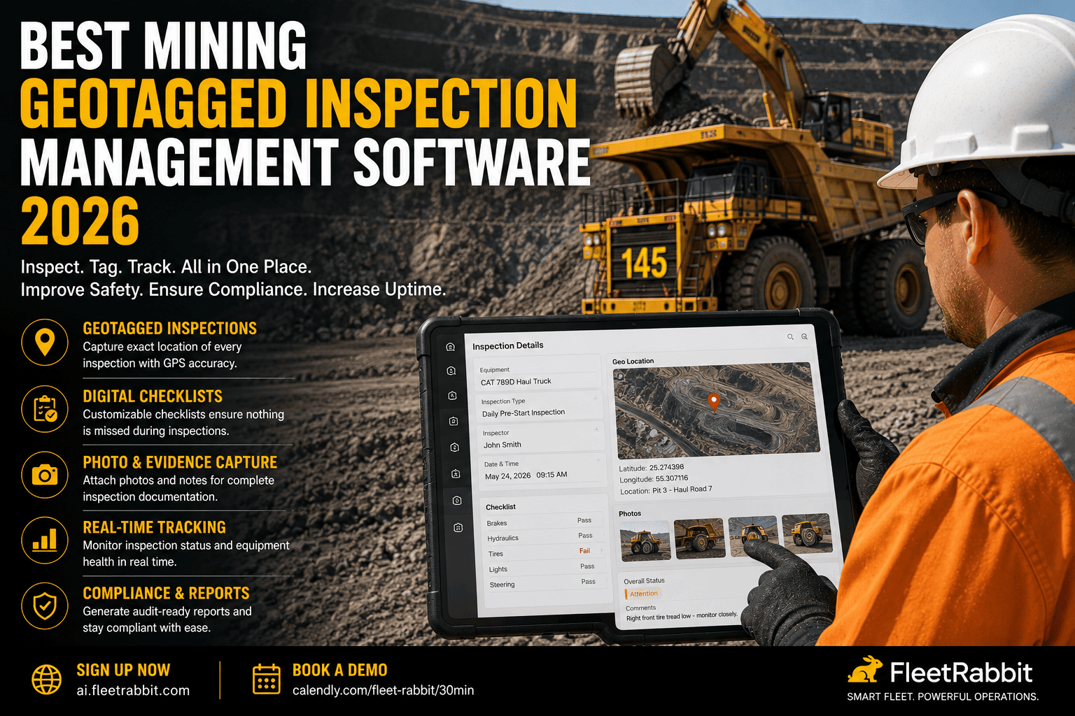
Mining geotagged inspection management software attaches GPS coordinates to every inspection entry and photo, proving an inspector was physically present at the exact location being documented, not just that a photo and timestamp exist somewhere. This matters most for dispersed inspection points that don't move to the inspector, like highwalls, berms, haul road sections, and fixed infrastructure, where location is the single hardest thing to fake and the easiest thing MSHA checks. FleetRabbit captures GPS coordinates automatically on every inspection so location-based compliance is never in question.
Why Location Verification Matters More Than Photo Verification Alone
Photo-verified inspections solved a real problem — they made it much harder to claim an inspection happened when it didn't. But a photo alone still leaves a gap for mobile equipment inspected at a fixed yard, and it leaves an even bigger gap for the parts of a mine that don't move: highwalls, berms, haul road segments, drainage structures, and ground control monitoring points. These locations spread across kilometers of site, and proving an inspector actually walked or drove to each specific point, rather than photographing the closest visible section and logging it against the wrong coordinates, requires more than a picture and a clock.
What Geotagging Actually Adds
A geotagged inspection record captures GPS coordinates at the moment an entry is submitted, tying that specific inspection to a specific point on the ground. Combined with a timestamp and a photo, it creates a record that answers three questions at once — what was inspected, when, and crucially, exactly where — closing the gap that photo-only or timestamp-only systems leave open.
What Geotagged Inspection Software Does
Beyond simply attaching coordinates to a record, a purpose-built platform uses location data to actively improve inspection coverage and make records genuinely useful, not just technically compliant.
Automatic GPS Capture on Every Entry
Location coordinates are captured automatically the moment an inspector completes an entry, requiring no manual step that could be skipped or forgotten. The record becomes location-verified by default rather than by extra effort.
Map-Based Inspection Coverage View
Instead of a list of completed checklists, supervisors see a map of the site with every inspection point plotted, making it immediately visible which sections have been checked recently and which haven't been visited in weeks.
Geofenced Inspection Zones
For sites with defined inspection zones — a specific highwall segment, a berm section, a drainage structure — software can confirm an entry was logged from within the correct geofenced boundary, flagging any submission that falls outside the expected zone for review.
Route-Based Haul Road Inspections
Haul road condition inspections benefit from GPS tracking that confirms an inspector actually traveled the full route being documented, rather than checking one visible section and logging the whole road as inspected.
FleetRabbit captures GPS coordinates automatically on every inspection entry, so location is never a question when an inspector reviews your records. Start your free trial and see your site's inspection coverage mapped out.
Photo-Only vs. Timestamp-Only vs. Geotagged Inspections
Digital inspection tools have matured in stages, and each stage closes a real gap while leaving a different one open for a mine site with widely dispersed inspection points.
| Verification Method | What It Proves | What It Misses | Best Suited For |
|---|---|---|---|
| Photo-Only | Something was physically photographed | Exact location and whether it matches the logged inspection point | Single-location equipment checks in a fixed yard |
| Timestamp-Only | An entry was submitted at a specific time | Where the inspector actually was when submitting it | Time-sensitive compliance windows, not location accuracy |
| Geotagged Inspection | Exact GPS location, time, and photo evidence together | Requires GPS signal, which some underground zones need alternative solutions for | Highwalls, berms, haul roads, and dispersed fixed infrastructure |
Where Geotagged Inspections Matter Most on a Mine Site
Not every inspection needs the same level of location proof, but for certain categories of mining inspection, geotagging isn't a nice-to-have feature — it's the difference between a record that holds up and one that doesn't.
Ground Control and Highwall Monitoring
Highwall stability inspections depend entirely on someone examining a specific section of wall closely and repeatedly over time. A geotagged history for each monitoring point lets engineers track condition changes at that exact location shift over shift, rather than relying on a general note that "the highwall was checked."
Berm and Barrier Inspections
Berms exist at specific points along a haul road for a specific safety reason, and an inspection that isn't tied to the correct berm location provides no real assurance that the barrier protecting a particular drop-off is actually intact.
Fixed Infrastructure and Drainage Structures
Culverts, sumps, and drainage infrastructure spread across a site are easy to under-inspect precisely because nobody has an easy way to see which ones have gone unchecked. A map-based view of geotagged inspection history makes those gaps visible at a glance instead of discovering them during an incident investigation.
What to Look for in a Geotagged Inspection Platform
Before choosing a platform, confirm it captures GPS coordinates automatically without requiring an extra manual step, supports offline GPS logging for remote pit areas with limited connectivity, provides a map-based coverage view rather than just a list of records, and exports location-tagged records instantly in a format ready for MSHA review.
Offline Capability Matters as Much as Accuracy
Many of the areas that need location-verified inspections most — remote highwalls, deep pit sections, underground zones — are exactly where connectivity is weakest. A platform that captures GPS data offline and syncs it once connectivity returns is essential, since a system that only works with a live signal will fail precisely where location proof matters most. This is where a connected platform like FleetRabbit earns its place, capturing and storing location data reliably regardless of signal strength at the moment of inspection.
The Bottom Line on Geotagged Inspections
A mine site isn't one location — it's dozens of them, spread across kilometers of haul roads, highwalls, berms, and fixed infrastructure that all need eyes on them regularly. A photo and a timestamp tell you an inspection happened somewhere. Geotagging tells you it happened exactly where it needed to, which is the one detail that matters most when a highwall shifts, a berm fails, or an MSHA inspector asks for proof that a specific point on your site was actually checked.
If your inspection records can't currently show exactly where each entry was logged, that gap is the first thing worth closing before it becomes a question you can't answer. You can start a free trial to see your site's inspection coverage mapped out in full.
A photo alone can't prove location. FleetRabbit captures GPS coordinates automatically on every inspection, giving you a map-verified record across your entire site that holds up the moment MSHA asks for it. Start your free trial or book a 30-minute demo to see it in action.