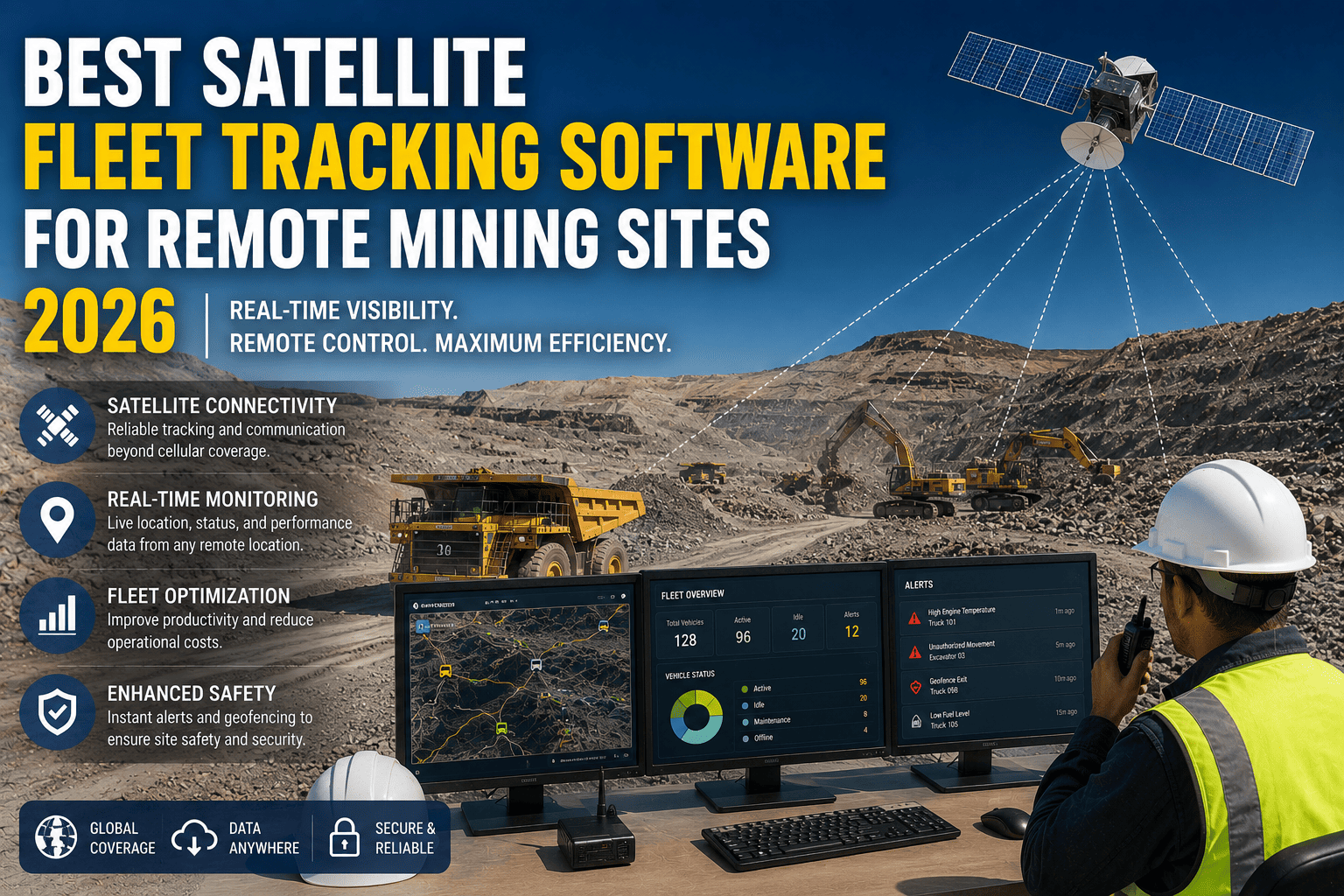
Somewhere right now, a haul truck is idling two hours into a shift and no one knows exactly where it is. Not because no one cares — but because the cell signal died the moment it rolled past the pit edge. Cellular coverage ends where mining begins. Satellite tracking is the only technology that keeps your entire fleet visible, accountable, and safe regardless of how far from civilization your operation sits. This guide tells you exactly what to look for, what to avoid, and why FleetRabbit is the platform mining operations across three continents are choosing in 2026.
The best satellite fleet tracking software for remote mining sites combines continuous GPS visibility beyond cellular coverage, offline data capture for underground operations, real-time equipment health monitoring, geofencing for blast zones and restricted areas, and intelligent data sync that controls satellite bandwidth costs. FleetRabbit delivers all of this in one platform — starting with a free trial, no credit card required.
Why Cellular GPS Simply Does Not Work for Remote Mining
Most commercial GPS fleet tracking software is built around a single assumption that feels so obvious it goes unstated: your vehicles are within range of a cell tower. For urban delivery fleets, suburban construction sites, or highway logistics, that assumption holds. For remote mining operations, it fails completely — and the consequences are not minor inconveniences. They are operational blind spots that cost real money every single day.
Open-pit walls block signal. Underground levels eliminate it entirely. High-altitude copper mines in the Andes, lithium operations in the Atacama Desert, iron ore sites in the Pilbara — these are places where the nearest cell tower can be 100 to 300 kilometres away. A fleet management tool designed for a delivery van on a city street stops functioning the moment a 250-tonne haul truck disappears over the pit edge. If you have been managing this with radio check-ins and end-of-shift spreadsheets updated from memory, you already know exactly how unreliable that picture is. Book a demo with FleetRabbit to see what genuine satellite visibility looks like on a live mining fleet.
The Real Gap Satellite Tracking Fills
Satellite fleet tracking closes the visibility gap by routing position and telemetry data through orbiting constellations rather than terrestrial cell networks. Whether your truck is at the bottom of a 400-metre open pit, on a haul road carving through a remote mountain range, or parked at a camp site with no infrastructure for 200 kilometres in any direction, satellite communication reaches it. The data — location, speed, engine status, fuel level, driver behaviour — transmits to your operations dashboard regardless of where on Earth the asset sits.
What to Look for in Satellite Fleet Tracking Software for Mining
Not every platform that claims satellite capability is genuinely built for the demands of active mining operations. The marketing language is nearly identical across vendors. The actual capability differences become apparent only when you ask the right questions — or when a mission-critical tracking gap appears in your data at the worst possible moment. Here are the features that separate purpose-built mining satellite tracking from generic GPS tools with satellite bolted on as an afterthought. Sign up with FleetRabbit and access every one of these capabilities from day one.
Always-On Position Logging
The platform must log GPS coordinates continuously with no gaps — not just when connected. On-vehicle storage queues data during any connectivity gap and syncs automatically when satellite link returns.
Multi-Constellation GNSS
Best-in-class satellite trackers use GPS, GLONASS, Galileo, and BeiDou simultaneously. Deep pit walls and mountain terrain can block some satellites — multi-constellation coverage maintains fix accuracy where single-constellation fails.
Geofencing for Blast Zones
Draw virtual boundaries around blast zones, restricted pit walls, refuelling stations, or haul roads. Receive instant alerts when any asset enters or exits, without requiring anyone to be watching the dashboard at that exact moment.
Engine Health Telematics
Position alone is not enough. Mining fleet tracking software must transmit engine temperature, oil pressure, fault codes, fuel consumption, and hours of operation alongside location data — via satellite when cellular is unavailable.
Bandwidth-Efficient Sync
Satellite bandwidth at remote mining sites costs significantly more than cellular data. The tracking platform must intelligently prioritise critical alerts for immediate transmission and batch routine telemetry for scheduled low-cost sync windows.
Multi-Site Central Dashboard
Operations with multiple remote mine sites need a single unified view, not one dashboard per site. Every tracked asset across every location — live positions, status, alerts, and maintenance schedules — visible from one screen.
How Satellite Tracking Pays for Itself on a Remote Mine Site
The conversation about satellite fleet tracking often gets stuck at the cost of the technology. That is the wrong starting point. The right question is: what is the cost of not having it? For remote mining operations managing fleets of haul trucks worth $3–5 million each, the operational losses from poor visibility dwarf any tracking software subscription. Book a demo with FleetRabbit and we will build a custom ROI model for your specific fleet and site configuration.
The Five Cost Categories Satellite Tracking Eliminates
Idle Time Losses
Studies consistently show that 15–25% of mining vehicle operating hours are spent idling without productive output. At fuel costs of $2–4 per litre for diesel in remote locations and equipment worth thousands per productive hour, idle time tracking alone generates payback within weeks. Satellite tracking makes idle time visible for the first time on remote sites where radio check-ins provided only rough location estimates.
Unplanned Equipment Downtime
A single haul truck out of service at a remote mine can cost $40,000–$80,000 per day in lost production. When satellite-transmitted engine data reveals developing faults — rising coolant temperature, abnormal oil pressure, fault code patterns — maintenance teams can schedule repairs during planned downtime rather than responding to breakdowns. FleetRabbit customers typically see 35% reduction in unplanned failures within the first quarter of deployment.
Fuel Theft and Dispensing Losses
Remote mine sites with limited oversight are among the highest-risk environments for fuel theft. Satellite tracking cross-references fuel dispensing records with vehicle location and engine run-time data. Discrepancies that previously went undetected for weeks are flagged within hours. Operations that have implemented satellite-monitored fuel management typically recover 8–12% of fuel budget annually.
Manual Site Visit Costs
Australian mining operators report cutting remote monitoring costs by up to 80% by replacing weekly manual site inspection trips with satellite-transmitted sensor data. When groundwater levels, environmental conditions, and equipment status transmit automatically via satellite, the weekly drive that took a full day and two staff becomes a 10-minute dashboard review.
Compliance Penalties and Insurance Costs
Satellite-backed, tamper-proof records of driver hours, equipment inspections, and haul road compliance eliminate the manual record-keeping gaps that generate regulatory penalties. Insurers increasingly offer premium reductions to mining operations with documented telematics programmes — typically 5–10% annually, which on large fleet insurance programmes represents substantial savings.
FleetRabbit puts every haul truck, excavator, loader, and support vehicle on one live satellite-connected map. Geofenced blast zones, idle-time alerts, fuel monitoring, and predictive maintenance — all visible from your operations centre regardless of how remote your mine site is. Start your free trial with 3 vehicles today.
Satellite Tracking Across Every Asset Type on Your Mine Site
Remote mining operations run mixed fleets of vastly different equipment — from 250-tonne haul trucks to light utility vehicles to fixed crushing and screening equipment. The best satellite fleet tracking software handles all of them through a single platform, giving operations managers one dashboard rather than five disconnected systems. Here is how satellite tracking delivers specific value across the assets that define a modern mining operation.
| Asset Type | What Satellite Tracks | Key Alert Type | Typical Value Delivered |
|---|---|---|---|
| Haul Trucks | Position, payload, cycle time, fuel burn, tyre pressure, engine health | Overloading, excessive idling, developing drivetrain faults | 35–50% reduction in unplanned downtime; 10–18% fuel savings |
| Excavators & Shovels | Operational hours, swing cycles, hydraulic pressure, bucket count | Hydraulic temperature anomalies, swing bearing vibration changes | Early fault detection 3–14 days before failure; planned repair scheduling |
| Drill Rigs | GPS position, operating hours, drill depth, equipment status | Geofence departure, unauthorised movement, engine fault codes | Blast zone compliance enforcement; theft prevention on high-value assets |
| Personnel Carriers | Driver behaviour, speed, route compliance, hours of service | Speeding on haul roads, fatigue risk hours, geofence violations | Safety incident reduction; MSHA/regulatory compliance documentation |
| Water & Fuel Trucks | Tank levels, dispensing records, route, driver ID, fuel reconciliation | Fuel dispensing discrepancies, unauthorised stops, tank level depletion | 8–12% fuel theft reduction; automated dispensing audit trails |
| Light Vehicles | Position, speed, seatbelt use, after-hours movement, geofence compliance | After-hours movement, restricted zone entry, harsh braking events | Safety compliance; insurance premium reductions of 5–10% |
FleetRabbit: Built for Where Other Software Stops Working
FleetRabbit was not adapted from a ride-sharing platform or urban delivery tool and then marketed to mining companies. It was built from the ground up for industrial fleet environments where connectivity is unreliable, equipment is high-value, and the operational stakes of a missed alert are measured in tens of thousands of dollars per hour.
One Live Map. Every Asset. Everywhere.
The FleetRabbit dashboard shows every tracked asset on a single satellite-connected live map — haul trucks, excavators, drill rigs, personnel carriers, fuel trucks, and auxiliary equipment. Position updates every 30–60 seconds via satellite when cellular is unavailable. When an asset moves underground or into a dead-zone pit, its last confirmed position, heading, and speed remain visible. The moment it resurfaces, the dashboard catches up automatically with a complete movement trail for the entire period out of contact. Sign up free and have your first assets live on the map within a single working day.
Geofencing That Protects People and Production
Drawing a geofence in FleetRabbit takes under two minutes. You set the boundary, choose which assets it applies to, define the trigger condition — entry, exit, or both — and specify who receives the alert. For blast zones, the alert fires the moment any vehicle crosses the boundary. For haul road compliance, alerts notify dispatchers when trucks deviate from approved routes. For refuelling stations, entry and exit times generate automatic service records. This transforms safety checks that depended on someone noticing into automated safeguards that fire regardless of who is watching.
Predictive Maintenance Over Satellite
Engine fault codes, temperature trends, oil pressure anomalies, and component wear indicators transmit via satellite from every tracked vehicle. FleetRabbit's predictive engine analyses these data streams and generates maintenance alerts when patterns indicate developing faults — typically 3–14 days before failure. Maintenance teams receive the alert, order parts, and schedule the repair during planned downtime. The same component addressed proactively costs 4–5 times less than emergency repair after failure. On a remote mine site where spare parts require days to arrive, that difference is the difference between a planned half-day service and a five-day production stoppage. Book a demo to see predictive alerts on a live mining fleet dataset.
Choosing the Right Satellite Fleet Tracking Software: A Comparison Framework
When evaluating satellite fleet tracking platforms for a remote mining operation in 2026, the decision framework needs to go deeper than feature lists and pricing pages. These are the dimensions that reveal how a platform will actually perform when conditions get difficult — and on a remote mine site, conditions always get difficult eventually.
True Offline Capability
Does data capture continue with zero connectivity, or does "offline mode" mean reduced functionality? The test: can a vehicle operate for 72 hours without any satellite or cellular connection and emerge with a complete, gap-free data history?
Hardware Mining Certification
What are the IP rating, operating temperature range, and vibration resistance specifications of the on-vehicle hardware? Consumer-grade telematics fails in mining environments within months. Demand IP67 or better and MIL-SPEC vibration ratings.
Satellite Network Partnership
Which satellite networks does the platform use for transmission? LEO constellations (like Starlink) offer low latency. GEO satellites offer wider established coverage. Hybrid LEO/GEO platforms provide the best combination of coverage and performance.
Bandwidth Cost Controls
Does the platform allow you to control what data transmits immediately versus what batches for off-peak sync? Uncontrolled satellite data transmission can cost more than the software subscription itself on large fleet deployments.
Implementation Timeline
How quickly can the full fleet be instrumented and live? Enterprise mining telematics suites often require 3–6 months of implementation. Purpose-built platforms like FleetRabbit deploy a full small-to-medium mine site in 1–5 days.
Scalability Across Sites
If your operation expands to a second or third remote site, can the platform scale without a new contract and a new dashboard? A unified multi-site architecture is essential for growing mining companies.
FleetRabbit's satellite fleet tracking gives you the live map, predictive maintenance alerts, geofenced safety zones, and multi-site visibility that remote mining demands. Most mine sites are fully live within one business day. No IT team required. No enterprise contract. Start with 3 vehicles free, then scale to your full fleet.
Frequently Asked Questions
Every shift your remote fleet operates without satellite tracking is a shift of invisible idle time, undetected developing faults, unverified compliance records, and uninvestigated fuel discrepancies. FleetRabbit ends the guesswork. See every asset, everywhere, in real time — and get your first actionable fleet insight within 24 hours of going live.